
The Toxic Legacy of Seattle’s Lost Cemetery
In 1912, gravediggers worked quietly through autumn nights in hard dirt to unearth 3,000 dead people along the Duwamish River.
The coffins in this potter’s field belonged to those who were poor, unknown, or didn’t have families to bury them. Loose silt and clay rolled off pine boxes as the diggers lifted the remains out of the ground.
Then the bodies vanished, and so did the bends of the waterway they had once rested within.
Georgetown’s lost cemetery is a little known piece of Seattle history, but it is also part of a larger story that still haunts the city to this day: a systemic trend of environmental injustice and degradation at the expense of those who call Duwamish Valley home.
More than a century ago, King County commissioners wanted to develop land along the river for factories and port activity. They hired undertakers to take the bodies from the eight-acre plot to a newly built crematorium, owned by the county. The project cost $685,000 in today’s dollars.
The plan was for 83 bodies to be burned a day and each of them to be placed in its respective urn. But the crematorium couldn’t keep up with the pace and instead started burning several bodies at a time. Evidence to identify the remains was destroyed.
“It was a huge mess. They ended up sweeping everyone together,’” said Cari Simson, an events producer and researcher at Friends of Georgetown History, an organization dedicated to preserving and presenting history about one of Seattle’s oldest neighborhoods.
“What we think is that, at the end of this, they just dumped all the ashes out in the river.”
At the direction of the U.S. Army Corps of Engineers, crews started excavation at the poor farm and its cemetery, destroying both. With little regard for the landscape and people, King County went on to establish a waterway commission and oversaw the dredging of the river to depths never seen before. This construction added 12 new miles of land along the Duwamish by pouring seven million cubic yards of mud and sand out along the riverbanks. That is enough earth to fill more than 2,000 Olympic-size swimming pools.
The river was now straighter and deeper—and that was better for industry.

Image: Seattle Met Staff and netsign33/shutterstock.com
Legacy of environmental injustice and degradation
The mouth of the Duwamish River, before it flowed into the Puget Sound, once had about a dozen channels running through its delta. Salmon swam with ease from the Sound and through the meandering river. This rich wetland served not only as a natural resource but as a home to the Duwamish Tribe for millennia. In the eyes of Eugene Semple, it was nothing more than a swamp.
Semple was the final appointed governor of the Washington territory before it became a state in 1889. He was committed to turning Seattle into a city with national renown. For Semple, the Duwamish River was the key to that transformation. In those first years of statehood, he used his influence to advocate for remaking natural landscapes like the river to accommodate infrastructure.
Around the turn of the century, he wrote to the U.S. Army Corps of Engineers, arguing that the “unsightly” estuary was better served for “the common good” as solid land for manufacturing industries. BJ Cummings—the founder of the Duwamish River Community Coalition (DRCC)— documented that letter in her book The River That Made Seattle. Semple’s perspective was largely influential in changing the river, forever, Cummings says.
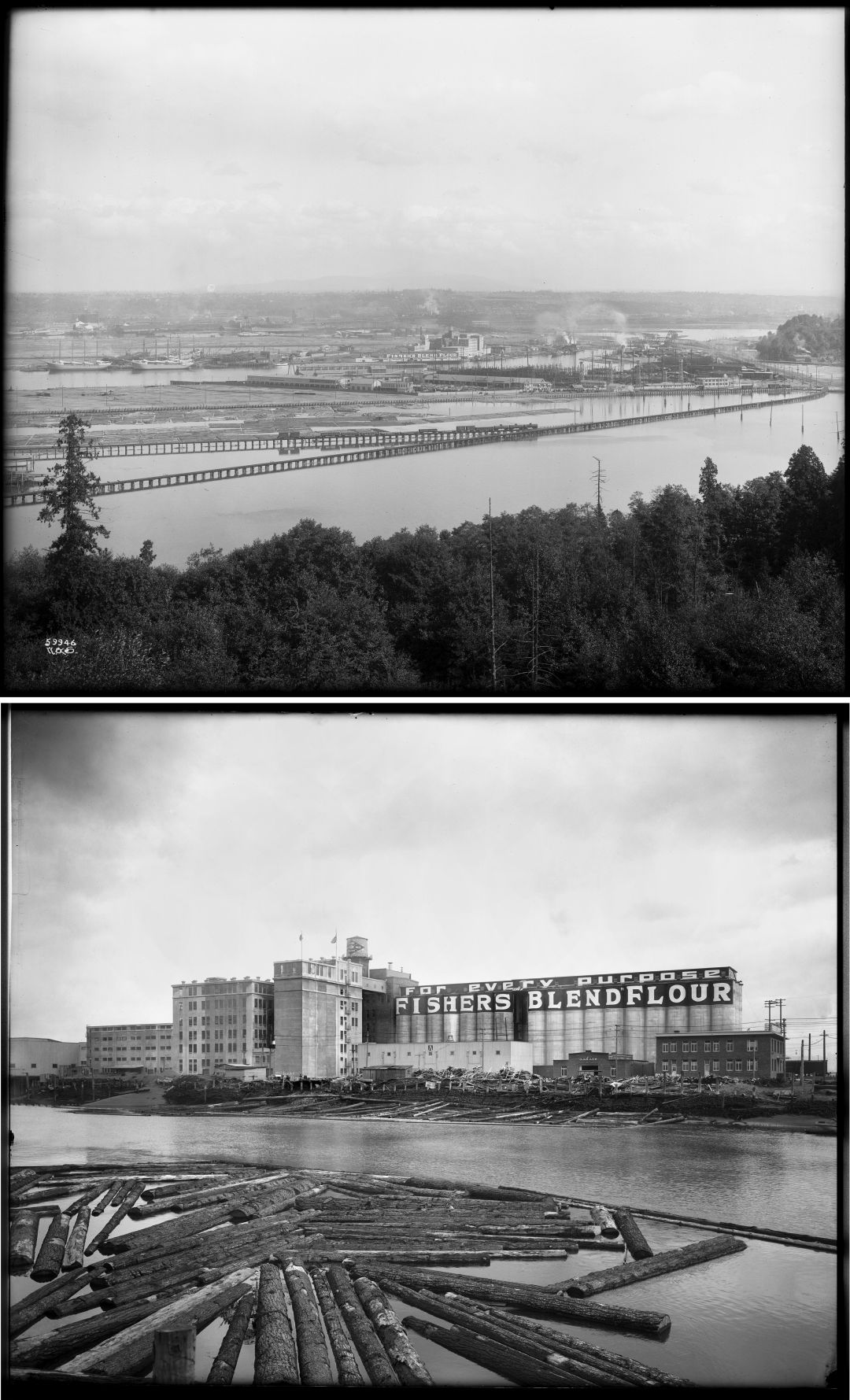
Above: The West Waterway of the Duwamish River crosses beyond the Coleman Creosoting Works on the West Seattle tideflats.
Below: Fisher Flouring Mills, located on the man-made Harbor Island.
Image: Courtesy MOHAI
The army corps went on to develop the river’s confluence into a two-prong canal—with man-made Harbor Island in the middle for port activity. In comparison to what was once a winding river, it is now almost a direct line running through modern-day South Park and Georgetown.
The engineered river cut off the watershed from its natural ties all the way to the Emmons Glacier on the northeastern flank of Mount Rainier. Severed from the White River and Lake Washington, the Duwamish watershed is a third of what it used to be.
“That’s pretty dramatic,” Cummings says. “The extent to which we diminished both the ecological role, and really, the overall economic role, at least in the traditional senses of the Duwamish watershed is pretty extreme… That set us on the path to becoming a Superfund site.”
After channelization, the river slowly degraded into a waste repository, becoming a slurry of wastewater and man-made chemicals that do not dissolve in water. The Environmental Protection Agency declared five miles of the river a Superfund site in 2001, making a cleanup eligible for federal support in resources and funding. Now, more than 20 years later, that work is just getting underway.

To this day, fish in the Duwamish still absorb decades-old chemicals like polychlorinated biphenyls (PCBs).
Image: Ashli Blow
The path to revival
Each fall, during the salmon run, anglers on the Duwamish competitively cast their fishing poles into the river from a pier that overlooks stacks of shipping containers at port terminals. But what they catch puts them at risk for a broad spectrum of effects including liver damage, respiratory problems, and skin reactions like acne and rashes. To this day, fish in the Duwamish still absorb decades-old chemicals like polychlorinated biphenyls (PCBs). Salmon are the only Duwamish fish health authorities say are safe to eat, because their migration patterns mean limited exposure to polluted waters.
“Everyone deserves to be able to fish in the river and to be able to eat what they catch. So that's kind of a big part of what really informs the kind of the cleanup standards that we advocate for,” says Jamie Hearn, Superfund program manager for the DRCC.
The DRCC, an ally organization of the Duwamish Tribe whose mission is rooted in an equitable environment for people and wildlife, has helped secure five polluted hot spots for early action cleanups under the Superfund site program. These have reduced the average PCB levels by 50 percent, according to the King County Wastewater Treatment Division.

Salmon are the only Duwamish fish health authorities say are safe to eat, because their migration patterns mean limited exposure to polluted waters.
Image: Ashli Blow
King County is part of a public-private partnership called the Lower Duwamish Waterway Group that also includes Boeing, the City of Seattle, and Port of Seattle. This group is charged with implementing the cleanup under EPA’s plan, direction, and oversight.
The group has hired contractors to carry out scientific work and community outreach for a cleanup plan that will take 10 years to implement followed by many years of long-term monitoring. So far, it has spent $200 million on waterway studies and early action cleanups. The group has yet to put a price tag on its upcoming work, but estimates it will take several hundred-million dollars to properly address the remaining contamination. The next stage will start in October 2024 when crews will dredge, extract, and cap sediment in the uppermost part of the Superfund site. Their work is divided into three phases, and crews will move down the river until they get to Harbor Island.
Hearn says this effort is a long time coming for generations of people in South Seattle, and she wants to make sure that history doesn’t repeat itself.
“Even when talking about this Potter’s field…it all ties into environmental justice,” she says. “There's just a long legacy of, you know, folks being displaced, and it is a big concern that we have as the river starts getting cleaned up and this area becomes a lot more desirable.”
To end this legacy of displacement once and for all, strategies must be developed through community-led approaches that protect the people who have historically been in the community; approaches that keep them in the place that they call home, Hearn says.
And that goes for both the living and the dead.
Photo Essay
SoDo's Duwamish River Is Visibly Healing
Don’t Fuhgeddaboudit
The Forgotten Black History of Seattle's Mrs. Pizza

Know Your Place
The Livingston Baker Building Has Tales to Tell
Trading Places