Lucky us: We live near some of the best hiking and mountain biking trails in the Pacific Northwest. Want to break a sweat? Take a stroll before lunch? There’s a trail for that.
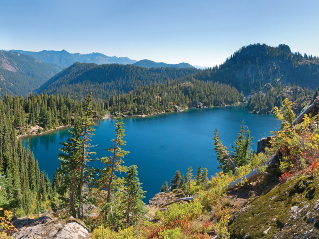
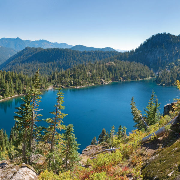
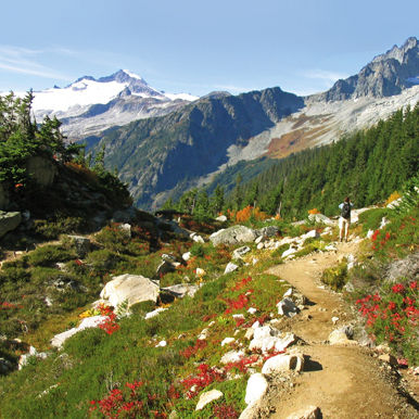
MODERATE TO DIFFICULT At times Rachel Lake looks like Madison Park Beach on a 90-degree day, but after Labor Day the crowds thin, leaving you free reign over the blueberry bushes. Follow the trail as it cuts through forest and valley, running parallel with its mate—the murmuring Box Canyon Creek. A little over three miles in, the path begins a steep ascent over roots, rocks, and fallen trees, then levels out a mile later in vast heather glades with a view of Rachel, a grande dame of a lake. Side trails snake toward a number of smaller alpine pools, but to the right is the narrow Rampart Ridge trail, an uphill grunt scaling Alta Mountain. Exhausted? Yes. Is this final push worth it? Oh yes. Enjoy a bird’s-eye view of the aforementioned lakes, winking like mirrors in the sun, and an eyeful of mountain giants Rainier, Adams, and Stuart. INSIDERTIP Bring the deet—the bugs can get nasty. —Hayley Poole
Round Trip 8–11 miles. Duration 6–8 hours. Distance from Downtown 70 miles. Permits and Passes None. Map Green Trails no. 207 Snoqualmie Pass. Find it.
Tiger Mountain: West Tiger 3
MODERATESeattle’s most accessible and manicured mountain trail is also the state’s busiest, home to the spandex set and dads with kid carriers. But the trail is wide and its travelers respectful of the woodland’s tranquility (the same can’t be said for all those jackhammering, black-backed woodpeckers). Plus, West Tiger 3—the lowest of three peaks on the west side of Tiger Mountain—boasts the best views and the most gradual elevation change. Follow the gently sloping trail as it switchbacks uphill for a 2,000-foot gain, with steeper grades near the top. Muscles burning? Relax at the summit with your new hiking pals, as you peer over the tree line at Mount Rainier, the Cascades—or paragliders hanging out in between. —HP
Round Trip 6 miles. Duration 3 hours. Distance from Downtown 20 miles. Permits and Passes None. Map Green Trails No. 204S Tiger Mountain. Find it.
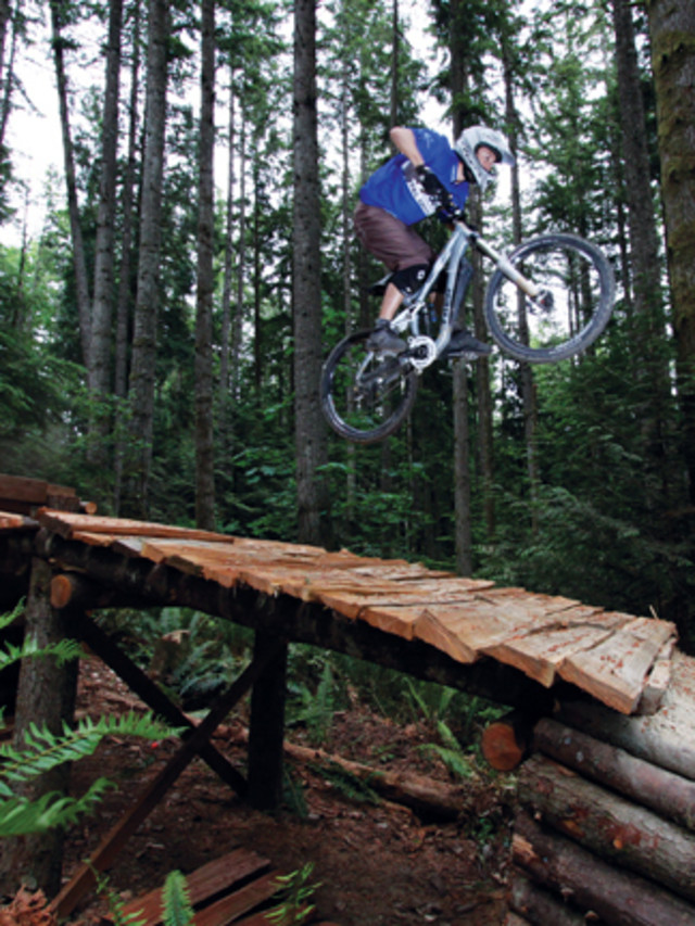
Duthie Hill Mountain Bike Park
EASY TO DIFFICULT Double black diamond drops. Miles of cross-country trails. Dirt jumps and “the world’s longest log ride.” Whether you’re new to mountain biking or a pro wearing free gear, there’s a trail for you at this brand-new 120-acre bike park on the Issaquah Plateau. It took more than 6,000 volunteer hours—courtesy of the Evergreen Mountain Bike Alliance—to prep the park for its May 22 opening; you won’t find fresher tracks anywhere else. INSIDERTIP
If the parking lot’s full, leave your car at Cascade Ridge or Endeavour elementary schools; the park’s about a mile from there. —Laura Dannen
Round Trip 5–6 miles. Duration Varies. Distance from Downtown 20 miles. Permits and Passes None. Map Evergreen Mountain Bike Alliance: Duthie Trails. Find it.
Paradise Valley
EASYOriginally a homestead in the 1880s, Paradise Valley’s nearly 800 acres in Woodinville now provide refuge for hikers, mountain bikers, horseback riders, and the occasional fox or coyote. The true beauty of this “paradise” is its relative obscurity: It opened as a conservation area a little over a year ago, and urbanites have been slow to take advantage of its 13 miles of well-marked, well—maintained trails. Routes get—and stay—muddy after a heavy rain, but slog on and you’ll see a patch of trilliums on the forest floor or a vernal pool of crooning tree frogs. Or a family running with its dog—just like at home(stead). —Craig Romano
Round Trip Up to 13 miles. Duration 1 hour to all day. Distance from Downtown 27 miles. Permits and Passes None. Map Snohomish County Parks and Recreation: Paradise Valley Conservation Area. Find it.
Trail Maps
If this article inspires you to get outside, remember the old motto: Be prepared. Purchase maps (greentrailsmaps.com) or print topographic maps (trails.com). Secure permits and passes through the U.S. Forest Service (fs.fed.us) and the federal parks department (nps.gov); or consider buying an annual Northwest Forest Pass for $30 from REI(rei.com), Metsker Maps (metskers.com), or the Washington Trails Association (wta.org).
Squak Mountain
EASYTread deep into the mossy forests of Squak Mountain and you’ll probably start daydreaming. It just happens. You lose yourself in the thick overgrowth of firs and ferns, imagining a time when Lewis and Clark were prowling around. Since the Bullitt family returned its swath of 600 acres to the state in 1972—on the condition that no logging take place—this stretch of the Issaquah Alps has returned to its roots, so to speak. And we’re luckier for it. —LD
Round Trip 8 miles. Duration 4 hours. Distance from Downtown 18 miles. Permits and Passes None. Map Green Trails no. 203S Cougar Mountain, Squak Mountain. Find it.