10 Best Hikes Close to Seattle
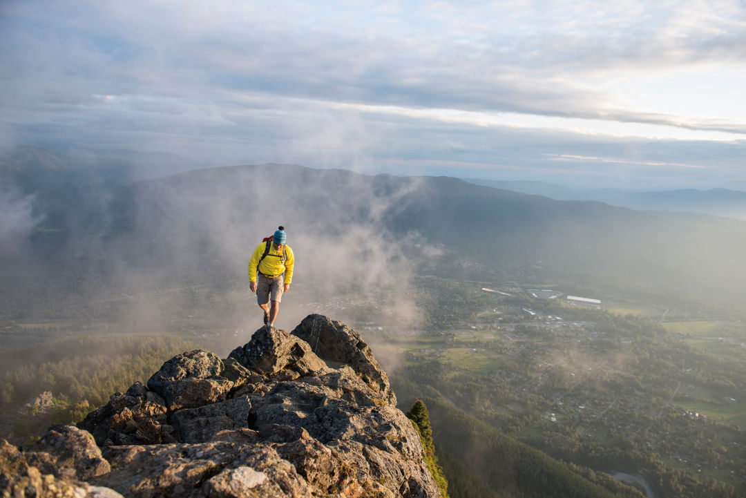
Mount Si comes to a rocky point at the true summit.
Image: Tandem Stock / Jim Meyers
Mount Si
Distance: 8 miles | Difficulty: Moderate | Trailhead: North Bend | Parking Fees: Discover Pass
Mount Si is Seattle’s unofficial favorite mountain—and officially its most glamorous thanks to its appearance in Twin Peaks. It’s easy to see why its rocky and imposing face and famous views attract hordes of area hikers. The strenuous 3,150-foot ascent is made worth the effort by one of the best mountain views in the Puget Sound region; most stop at the base of the bald “haystack” summit, while the brave scramble to the very top.
Rattlesnake Ledge
Distance: 4 miles | Difficulty: Moderate | Trailhead: North Bend | Parking Fees: None
There’s no wait for the spectacular sites on this well-loved route; the trail begins at fisherman-friendly Rattlesnake Lake and climbs from there past mossy boulders and through gentle switchbacks. The 1,160-foot climb ends at the at rock known as Rattlesnake Ledge, a spectacular natural viewing platform pointed east into the Cascades. Take care near the edges; the drop-offs are abrupt and steep.

Snow Lake shines even when winter melts away.
Snow Lake
Distance: 7.2 miles | Difficulty: Moderate | Trailhead: Snoqualmie Pass | Parking Fees: NW Forest Pass
The parking lot at Alpental Ski Area does summer duty as the trailhead for a well-trampled path. There are multiple sets of switchbacks on the way and a few meadows to cross before reaching this picturesque mountain pond; a side trip to the Source Lake viewpoint is worth the mile-long detour. Snow and ice persist well into summer, especially at the crest of a saddle and on the descent to the lake. Despite the campsites and old cabin ruins just off the trail, not to mention the throng of hikers, the lake retains untamed charm.
Coal Creek Falls
Distance: 2.5 miles | Difficulty: Easy | Trailhead: Newcastle | Parking Fees: None
This Cougar Mountain trail is family friendly, well maintained, and laden with mossy boulders, spring wildflowers, and various ferns. Wander under thick maple, alder, and cedar trees, and follow the small but mighty Coal Creek through a deep ravine, past old mine shafts and other coal-mining remnants from the late 1800s. Now reforested, Coal Creek Park is a rugged surprise among the suburban hills. The grade is relatively flat—more a place to stretch the legs than to feel the burn.
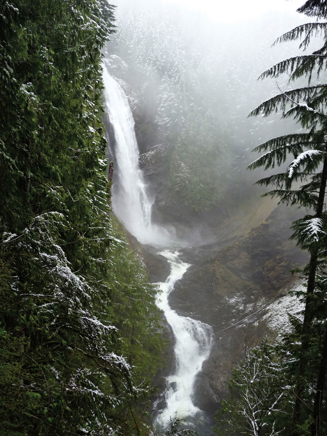
Image: Dana Henry Photography
Wallace Falls
Distance: 5.6 miles | Difficulty: Moderate | Trailhead: Highway 2 | Parking Fees: Discover Pass
The sheer power of these wooded waterfalls has a way of silencing even the crowds that line its trail on summer weekends. The hike hits a three-tiered cascade, with the middle section alone tumbling more than 250 feet. Stay behind guard rails, since the river banks are more treacherous than they look. Add mileage by tacking on a side trip to placid, uncrowded Wallace Lake (another 3.4 miles).
Billy Frank Jr. Nisqually National Wildlife Refuge
Distance: 5 miles | Difficulty: Easy | Trailhead: Olympia | Parking Fees: $3 Daily Fee
The name is a mouthful but a well-earned salute to a Native American environmental leader. The Nisqually Estuary trail at the foot of Puget Sound is an easy trek on boardwalks elevated above the tide flats. Spot beavers and weasels, not to mention birds from ducks to waxwings; more than 200 species migrate through the spot annually. A section is in gravel but it’s still largely wheelchair-accessible.
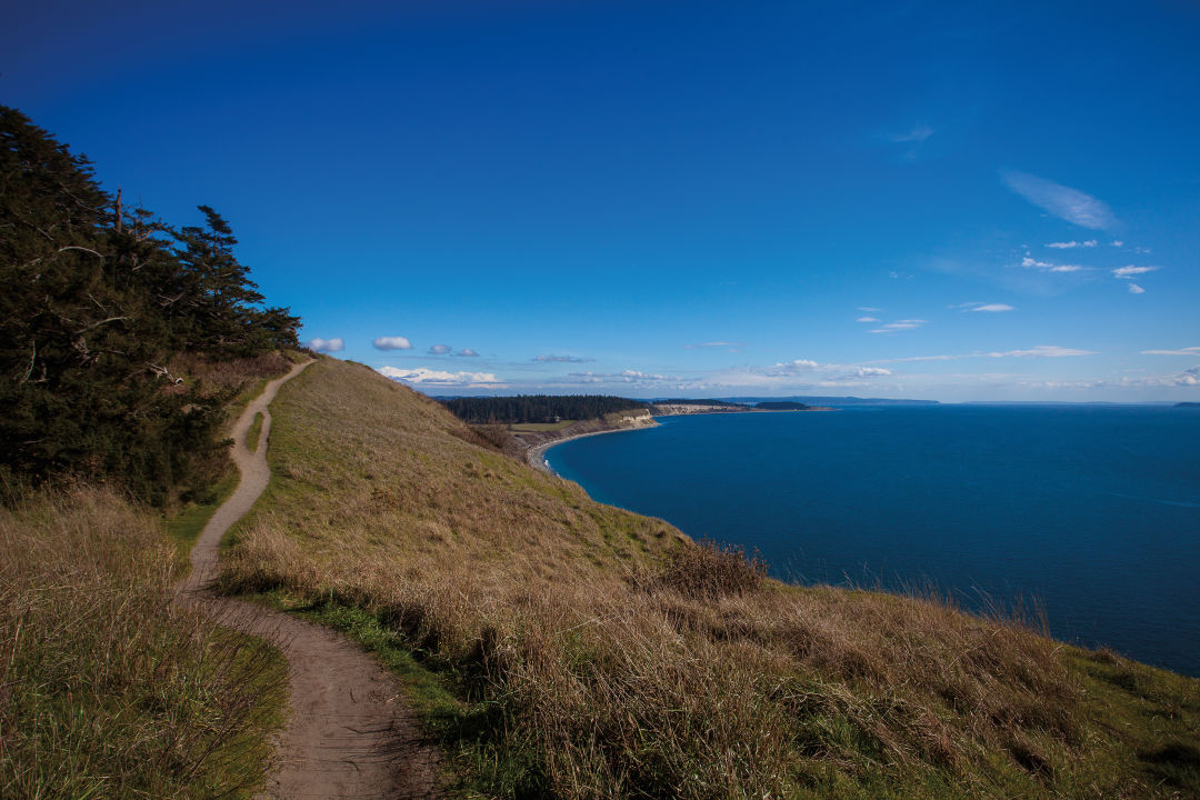
Image: Alison Klein
Ebey's Landing
Distance: 5.6 miles | Difficulty: Moderate | Trailhead: Whidbey Island | Parking Fees: Discover Pass
Walk across golden bluffs that tower above the surf of the Puget Sound, then wander along a beautiful beach for views of snow-capped Olympic Mountains. There are two ways to get to the Bluff Trail: from the Prairie Overlook trailhead, or at the seaside parking lot at the end of Ebey’s Landing Road. Home to 1850s homesteads, abundant birds, and maritime beauty, the route offers some of the best hiking on Puget Sound.
Poo Poo Point
Distance: 3.8 miles | Difficulty: Moderate | Trailhead: Issaquah | Parking Fees: None
Start in a big field just south of Issaquah, pass the carving of a winged lion, and head up more than 1,500 feet of Tiger Mountain on what’s called the Chirico Trail. Marc Chirico, owner of Seattle Paragliding at its base, created his namesake route to reach the launch ramps cut into the side of the mountain; eat lunch and watch paragliders step off into the sky and sail over treetops. And sure, giggle at the Poo Poo moniker: The point is named for the steam whistles of old logging trains, but these days you’re more likely to hear “oohs” and “ahhs.”

Image: Courtesy Grant Roush
Mailbox Peak
Distance: 9.4 miles | Difficulty: Hard | Trailhead: North Bend | Parking Fees: Discover Pass
This is one for the experienced hikers. Climb long switchbacks up 4,000 feet through airy forest, then emerge at a boulder field before open meadows to the summit. True to its name, the peak is topped with the namesake mailbox, mounted on a stone base and maintained by volunteers. Hikers coat it in stickers and stock it with stuffed animals, notes, or even beers. Leave an item, take an item, and enjoy a breathtaking view of Mount Rainier and the Middle Fork of the Snoqualmie River.
Lake Serene
Distance: 8.2 miles | Difficulty: Hard | Trailhead: Highway 2 | Parking Fees: NW Forest Pass
The trudge to Lake Serene is a beast of a climb up stone steps, gaining 1,300 feet in a mile and a half. It takes effort to finish the remaining half mile, but the rewards are great. Nestled within a forest thicket, against the northern face of Mount Index, the sparkling glacier-fed lake lives up to its name. Picnic atop Lunch Rock, a smooth stone slab that sits at the cerulean water’s edge. Or for those looking for a quicker cool-down, consider cannonballing into the watering hole—it was looking too serene anyway.
*All distances round-trip


