Lucky us: We live near some of the best hiking and mountain biking trails in the Pacific Northwest. Want to break a sweat? Take a stroll before lunch? There’s a trail for that.
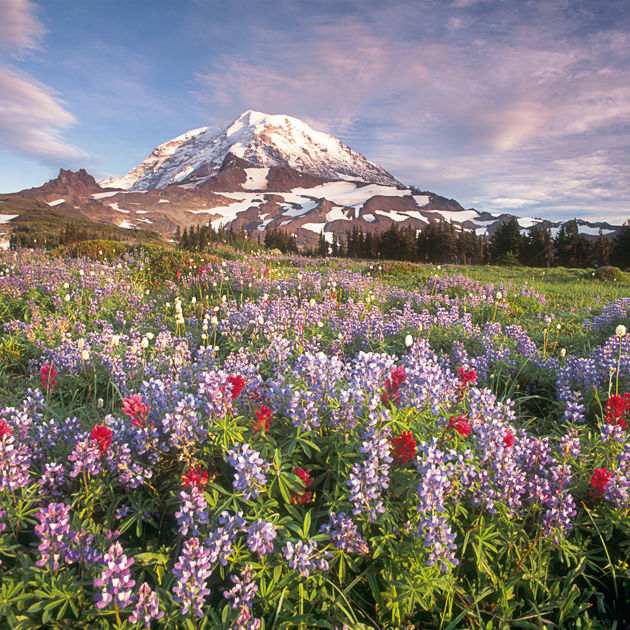
MODERATE If you think nothing compares to Mount Rainier’s Paradise, with its dazzling wildflowers set against an icy backdrop, you haven’t seen Spray Park. Located on the quieter northwest side of the mountain and accessible by a bumpy dirt road, Spray gets a fraction of the foot traffic at heavily touristed Paradise. Wander along the Wonderland Trail past aptly named Spray Falls—splashing 300 feet down a cliff face of volcanic andesite rock—to this magnificent alpine garden, lush with purple lupines that match shades of the sunset. INSIDERTIP Wildflowers are optimal in late July. —Craig Romano
Round Trip 6 miles. Duration 4 hours. Distance from Downtown 75 miles. Permits and Passes National Park Entrance fee; dogs prohibited. Map Green Trails no. 269 Mt Rainier West. Find it.
Kendall Katwalk
MODERATE TO DIFFICULT At first glance, the Katwalk is intimidating. Who really wants to walk along a ledge cut into a granite cliff more than 1,000 feet above the ground? But the trail’s wider than most, and as safe as a tried-and-true trek into the Grand Canyon. Plus, it’s only a small part of a beautiful hike along the Pacific Crest Trail from Snoqualmie Pass, with views of Red Mountain along the way. INSIDERTIP
Never attempt to cross the Katwalk when there’s lingering snow. —Laura Dannen
Round Trip 11 miles. Duration 7 hours. Distance from Downtown 55 miles. Permits and Passes Northwest Forest Pass. Map Green Trails no. 207 Snoqualmie Pass. Find it.
MODERATE TO DIFFICULT Beware: This trail has split personalities. At 1.7 miles, bear to the right and you’re on the Jekyll route: a short, moderate trek to the 100-foot Bridal Veil Falls, meandering along creek beds and up stairs to a waterlogged boardwalk and viewing platforms. Chances are you’ll get wet, though that’s as aggressive as this trail gets. But head to Lake Serene and out comes Mr. Hyde: a beast of a climb up stone steps, gaining 1,300 feet in a mile and a half. It takes effort to finish the remaining half mile, but the rewards are great. Nestled within a forest thicket, against the northern face of Mount Index, is the sparkling glacier lake living up to its name. Catch your breath and picnic atop Lunch Rock, a smooth stone slab that sits at the cerulean water’s edge. Or for those looking for a quicker cool-down, consider cannonballing into the ol’ watering hole—it was looking too serene anyway. —Hayley Poole
Round Trip 4–8 miles. Duration 2–4 hours. Distance from Downtown 55 miles. Permits and Passes None. Map Green Trails no. 142 Index. Find it.
Skyscraper Mountain
MODERATE
No pigeons cooing on the ledges of this skyscraper. Instead, you might see eagles or mountain goats as you approach the mountain’s easily attainable 7,078-foot summit. Start from Sunrise Visitor Center and head along Wonderland Trail, which cuts across alpine tundra and through meadows of asters and lupine. Marmots whistle encouragement as you hike 1,000 feet up to the boot-beaten path to Skyscraper Mountain. Though the windswept summit feels a bit precipitous, it’s as safe as peering from behind the guardrail atop the Empire State Building, with 360-degree views of Rainier Park’s finest: the West Fork of the White River and lush green of Berkeley Park below, Sluiskin Mountain, and of course, Mount Rainier herself. INSIDERTIPNo shade and no shelter—avoid in bad weather. —CR
Round Trip 8.5 miles. Duration 5 hours. Distance from Downtown 100 miles. Permits and Passes National Park Entrance fee; dogs prohibited. Map Green Trails no. 270 Mt Rainier East. Find it.
REWARD
At the western entrance to Mount Rainier National Park in the oh-so-tiny town of Ashford is historic Copper Creek Inn (35707 State Route 706 E, Ashford, 360-569-2799; coppercreekinn.com), home to Copper Topper cinnamon buns the size of a sumo wrestler’s fist and the best piece of blackberry pie we’ve ever had. Sure to fortify any hike.
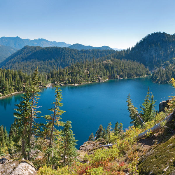
MODERATEIn the early twentieth century, this sprawling valley was overrun by prospectors searching for the mother lode. Nowadays, scores of hikers and backpackers cash in on Spider’s priceless scenery instead: old-growth forests, glacier-fed Phelps Creek, and a mile-long carpet of wildflowers surrounded by towering jagged peaks. The trail to the meadow is gentle—ascending a mere 1,300 feet in five miles—and once you’ve arrived, there are plenty of fine lunch spots along the creek. After a bite, consider pushing on one mile farther to Phelps Basin, a quiet cirque that’s perfect for an afternoon nap. —CR
Round Trip 10 miles. Duration 5 hours. Distance from Downtown 130 miles. Permits and Passes Northwest Forest Pass. Map Green Trails no. 113 Holden. Find it.
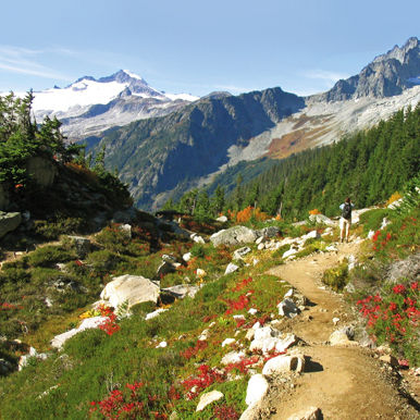
Carne Mountain
DIFFICULT The mountain, named after an English clergyman rather than Spanish meat (it’s “carn,” not “carnay”), offers panoramic views of the region—it just takes some commitment to get there. To reach the summit, hikers must overcome a steep set of seemingly endless switchbacks for an elevation gain of 3,600 feet (ouch). If you panic at the trailhead, you can always reroute to Spider Meadow. But hang on and, three miles farther, there’s a grove of larches that turn golden in the fall. Even the final ascent is softened by lupine, scarlet gilia, phlox, and asters lining the path. Once atop the 7,085-foot peak, face the four horizons and take it all in: the glistening ice of cloud-piercing Clark Mountain to the west; the fortress of Mount Stuart, king of the Enchantments; and to the north, Mount Maude, mighty matron of the Entiat Range. It’s practically a religious experience. —CR
Round Trip 8 miles. Duration 6 hours. Distance from Downtown 130 miles. Permits and Passes Northwest Forest Pass. Map Green Trails no. 113 Holden. Find it.
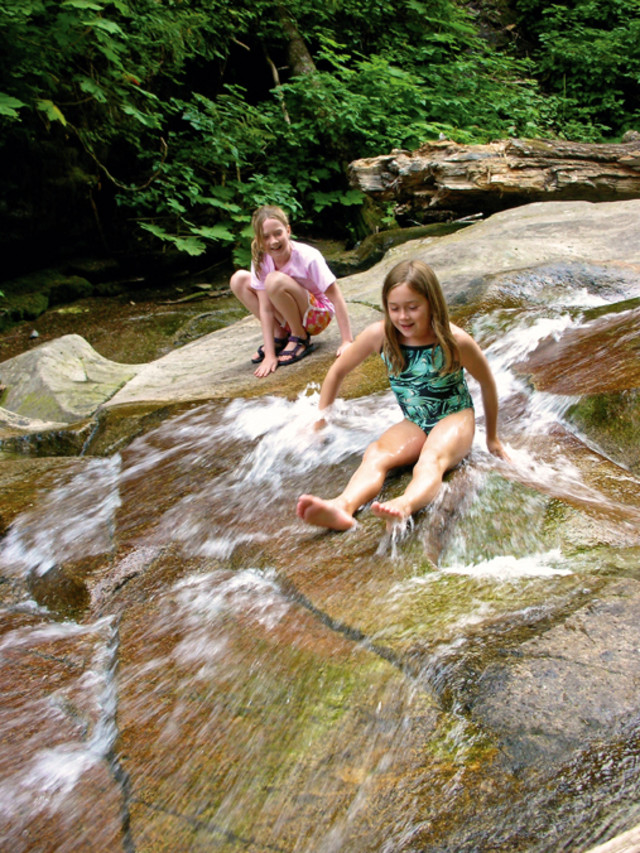
EASY You don’t have to go far off I-90 to find free fun in the summer: Denny Creek rushes down a smooth granite slab, creating a natural water slide with a shallow pool below. Bring the kids and the swimsuits, trek a mile and a half to the slide, then wander another half mile for photo ops in front of Keekwulee Falls and the smaller Snowshoe Falls. —LD
Round Trip 4 miles. Duration 2 hours to all day. Distance from Downtown 50 miles. Permits and Passes None. Map Green Trails no. 207 Snoqualmie Pass. Find it.
Talapus and Olallie Lakes
EASYKids will love everything about this winding trek through the Alpine Lakes Wilderness. You get to cross bridges and raised walkways, tromp through boggy sections of trail, and mingle with deer at the water’s edge. The snow-fed lakes are both frigid, but should be swimmable by mid-August. Expect company. —LD
Round Trip 4–6 miles. Duration 2–3 hours. Distance from Downtown 50 miles. Permits and Passes Northwest Forest Pass. Map Green Trails no. 206 Bandera. Find it.